


MARCH 2025
54°09'51.1"N 1°35'43.8"W
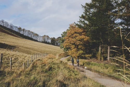
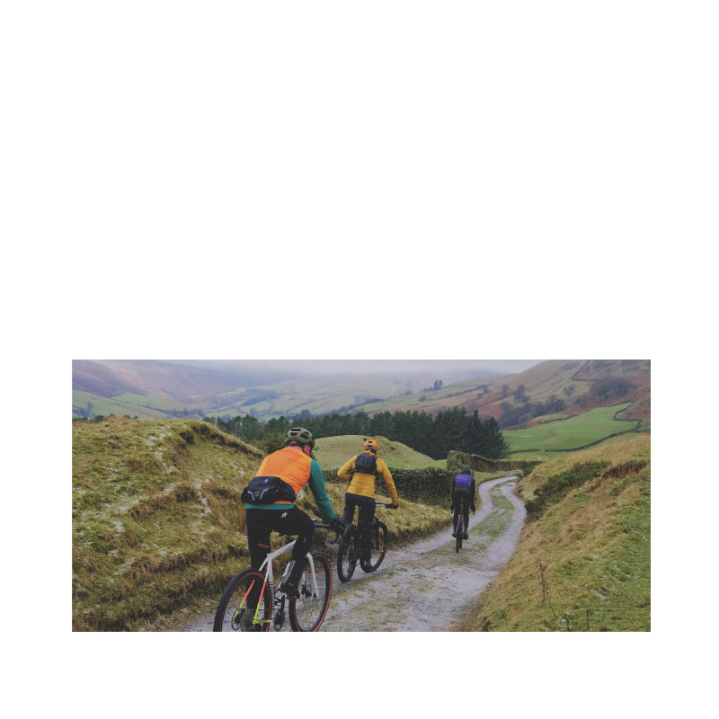
The Scar House / Dales Edge loop is an absolute classic piece of easy access wildness in the Nidderdale National Landscape area on the eastern edge of the Yorkshire Dales. It’s famous for its incredible panoramic views, long descents and challenging climbs on mostly rocky trails that are rideable all year round.
In its current (2025) relatively groomed state you’ll get round on a gravel bike if you’re careful of the rocks and have legs of steel. You’ll definitely have an easier time most of the way round on an MTB. There’s no big jumps or savage rock gardens though so if you’ve got a choice bring your lightweight XC bike rather than your long travel Enduro rig.
We always like to give you more than you expect at Polaris though so Guy has used his local knowledge to add 20km of fast moorland trails and fun bridleway.
POLARIS SCAR HOUSE EXTRA
49.8KM, 1,136M VERTICAL
Start and finish point - The route starts and finishes at Kirkby Malzeard which also adds better parking and facilities than the normal start at Ramsgill and less road miles than starting at Pateley Bridge. Kirkby Malzeard is 11 miles west of the A1/A19 junction at Dishforth.
The GPX file for the route and a Strava Fly Through animation are on this page but make sure you watch Guy’s video to get an idea of the terrain, the incredible views and how temperamental the weather can be.
Stops & shops
There are no public toilets in Kirkby Malzeard but there are loos at St Andrews church and Queen’s Head pub if you ask Jesus or the landlord nicely. Kirkby Malzeard does have an excellent village shop, and a butchers/grocers though.
En route How Stean (20.5km) has a cafe, shop, toilets and car park. Middlesmoor (22.5km) has an excellent pub and Scar House dam (26.5km) has toilets and a weekend cafe in summer. You’re literally on your own after that until the finish though so pack snacks accordingly.
Ripon (6 miles east of Kirkby Malzeard) has bike shops, supermarkets, petrol stations and a small hospital.
Watch out for
If you’ve watched the route video you’ll see the weather can change really quickly in upper Nidderdale so be prepared with extra layers and a survival bag.
The fords on the first off road section are either rocky or slippery underneath and can be deep after rain. Treat them with care and use the footbridges at each one if you want to stay dry.
Ramsgill descent (13.5km) is 3km long and potentially very fast. Watch out for a couple of big water bars and several gates as well as a steeper, wetter and rockier section at the bottom.
The short descent into How Stean (20km) is popular with walkers and school parties and goes through a farm so be sensible with your speed.
Scar House descent (25.7km) is fast with loose rocks in the flat turns at the top and bottom. It can also be popular with walkers and even 4x4 drivers so don’t go daft.
Be ready for the steep descent and even steeper climb out of Woo Gill (29km) too.
Route information
Kirkby Malzeard - Dallowgill 0-8km
It’s a nice easy start as you roll down Kirkby Malzeard high street waving to the adoring crowds who will be thanking you for parking considerately. Follow the curve of the road left out of the village and then take the first right following the slightly rising road towards Dallowgill. As it drops down again at 3km look out for the bridleway entrance at 3.3km and enjoy the gentle loose descent to the first ford. This one is normally quite shallow so you can splash through like a hero. The second one is much deeper with some big rocks in so let your mates do that first once you’ve got the camera out. Warm your feet back up on the steady road climb all the way to the T junction at 5km where you turn left for a km then right downhill through the tiny hamlet of Dallow. The only wooded descent of the whole route drops you down to another ford around a sharp corner. This one is always shallow although it can be slippery so be careful as it’s early for a full dunking. Climb up the steep, twisting climb to the road where you’ll double back westwards at 8km.
Dallowgill - Ramsgill 8-17km
Let’s be honest here, the next 5km are pretty much all uphill and often into a headwind. The descent it earns you is well worth it though. That means it’s time to settle in to a sustainable pace on the road and catch up on the group gossip while having a drink and a snack and taking in the probably deserted moorland views. This bit smells amazing when the heather is out too. The road gives out and turns lumpy and loose after Stope Bridge with a km to go. A hundred metres after this you’ll realise that the pace you thought was sustainable might have been a bit quick and the gossip will stop and the cursing will begin. The descent REALLY is worth it though. Coax your colleagues to the gate at the top for the first reveal of Nidderdale valley stretching out before you. Well, it will if the weather is playing nice but let’s not dwell on that shall we.
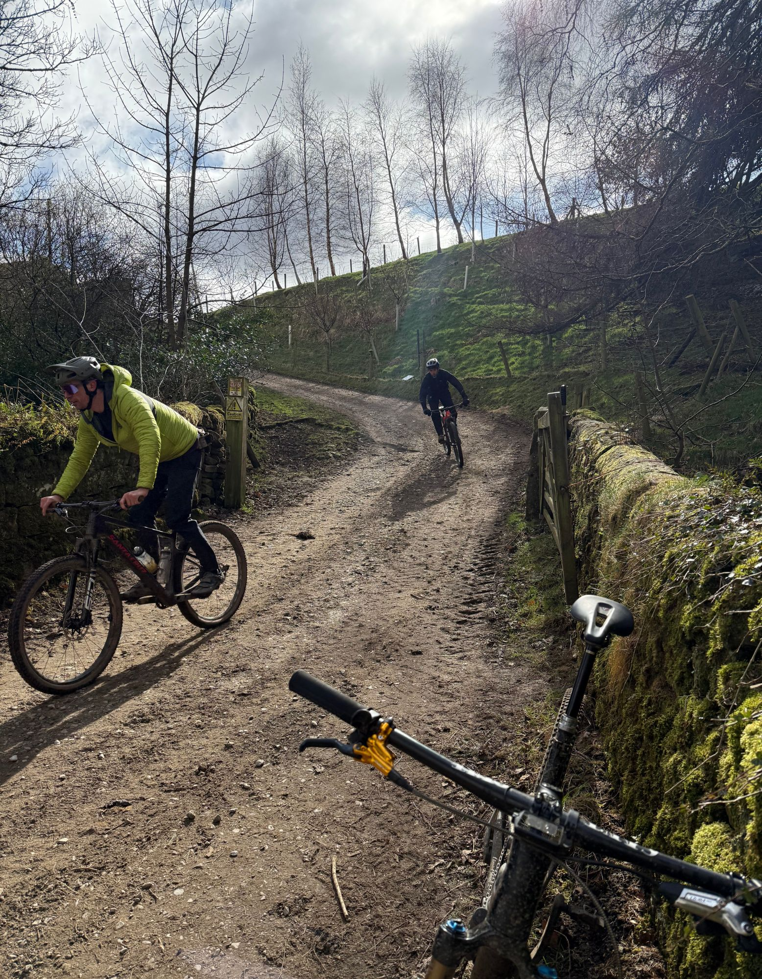
Navigation is blissfully simple from here as you just follow the double track straight down the hill, watching out for a couple of rocky curves on the top open section. Once you start getting to the dry stone walls you’re gambling with gates. We got incredibly lucky when we were filming as they were all open for a clean run, but keep your fingers on the brakes just in case sheep, ramblers or farm traffic are hiding round the next corner anyway. The final section can be quite tasty in wet weather too and it’s where the biggest rocks have ended up. It rolls out into a farm with a few houses and a popular bridleway coming in from the left too, so slow right down and be sensible.

Ramsgill - Howstean 17-20.5km
At Ramsgill bridge you can turn right up the road to How Stean, but we’re turning left and then hooking right to enjoy the bridleway option on the west side of the valley. Again there’s a few gates, sheep and hikers to potentially contend with but it’s a lovely pastoral rise and fall roll along mostly well surfaced farm track past an old farm and trademark Yorkshire Dales field barns.
Watch out for kids heading up for wholesome outdoorsy fun at Blayshaw Gill then enjoy the views over to Lofthouse and up the valley to where you’ll be heading next as you roll towards Studfold Farm. Then it’s down the cobbly descent past the activity centre - careful of school kids during the week and families in the holidays and the cobbles themselves in the wet. Then it’s a short kick climb on the road to How Stean cafe to check out the cakes and glass floor views of the gorge. You can camp here too and all the other activities like canyoning and caving make it a fun place to make a weekend or even a week out of.
How Stean - Scar House 20.5-27km
At some point you’re going to have to leave the cafe and face up to the toughest climb of the whole route. Not as long as the climb from Dallowgill at ‘only 4km’ but with 260m of vert it’s a decent innings. It doesn’t mess about either, starting fairly steep on the road and then kicking up into a double arrow wall for the last 100m into Middlesmoor village. Hopefully you won’t need a more serious intervention at this point than a pint at the excellent Crown Hotel but there is a defibrillator in the old phone box. Crawling out of the village, it’s off the tarmac and only a steady, loose, rocky trundle all the way to skyline. Don’t just stare at your front wheel and curse though as the views unfolding around you are awesome. Particularly if you take a moment to look over your shoulder down the lane to see Bouthwaite reservoir glinting in the distance. A long false flat that drags a lot more than it seems like it should - Polaris is a brand based on honesty OK? - will also put any weather that fancies making things more challenging in your face too. Again, the descent you earn is very well worth it, but be sure to stop at the top as the view over Scar House to Great Whernside and Dead Man’s Hill open up before you like a big blockbuster movie moment.
Scar House descent reverses the order of Ramsgill descent with the rocky corners at the top, the muddy bit in the middle and then the fast and loose section towards the bottom. Again, it’s a popular place at the weekend so watch your speed. The corners towards the bottom are flat/off camber, rocky and loose too, which can make them interesting if you go in a bit hot. Roll down to the seriously impressive 600m long reservoir made out of more than a million tons of stone a century ago. There’s a loo, car park and a cafe here on summer weekends too.


Scar House - Dale’s Edge 27-35km
As you lump and bump up the short cobbled climb there is the potential to extend the route big time by heading up to the deserted village of Angram (more on that later) and then either over into upper Wharfedale or Colsterdale. You’d be creating a big old epic with limited return ticket options by doing that though and it’s not like the eponymous Dale’s Edge section of the ride isn’t glorious anyway. The couple of gate stops on the first section are a chance to look back towards Scar House and take the classic route picture, and you’ll also be able to see the footings of the village that housed 2500 construction workers for 15 years while the dam was built. Then it’s a splash through a small ford, another gate and then the big U bend section of Woo Gill. We’re pretty sure this isn’t named after the noises often made trying to negotiate the tight rocky left hander halfway down the descent, but it might be. You’re more likely to be grunting and groaning up the super steep far side with its zero grip mix of gravel over concrete too, and once you’re up that there’s another ford and steep climb before things level up a bit towards the shooting house.
You can drop down into the valley on a fast grass bridleway here if you want to add some extra elevation but I normally stay high to make the most of the views and the fast rolling rocky double track that contours around the top edge of the dale for the next 3km. A short rise and then short but fun rocky descent take you to the second shooting hut which offers potential refuge if the weather is really bad. Otherwise, it’s time to climb slightly away from the dale edge to meet the road up from Lofthouse for the final part of the ride.
Dales Edge - Kirkby Malzeard 35-50km
If you’re thinking you’ve done more climbing than descending so far as you roll up another rocky slope, this is where the real payback begins. I’m not saying it’s all downhill, and there are still a couple of short rises too, but once you’ve passed the two big rocks of Jenny Twigg and her Daughter Tib you’re losing 230m in height over the next 12km so it’s definitely trending downwards from here. If you’re wondering about the weird names of the rocks, they’re said to be the remains of the landlady and her daughter from now deserted Angram village who were petrified after murdering some Scottish cattle herders whose dog tipped off the law. Which thinking about it, sounds like Scooby Doo was invented in Nidderdale.
The next 6km is prime moorland double track with a mix of sandy sections but a lot of loose rock and some long double / triple rut segments. These are great fun on a MTB but if you’re running skinny tyres or a gravel bike go steady to avoid shredding your tyres. Now is a good time to check your bottles aren’t going to rattle out too. In terms of nav it’s dead simple. Take the right option to stay high at the first fork and then the left option to stay high at the second fork. This will take you straight down to the wide open cobbled drove road with a couple of chicanes before your turn hard left for a ford splash and then a final suitably foul but short off road climb up to Foulgate farm. BTW if you’re wondering why we don’t take the bridleway straight back to Kirkby at this point it’s either soggy, full of bulls or both, but if you fancy some beef with the locals while fighting through a bog be our guest.
Otherwise, it’s a nice easy 4km road roll in via Grewelthorpe back to Kirkby Malzeard to see what the village shop and butcher has left for you.