


JAN 2025
53°22'11.0"N 1°41'49.7"W
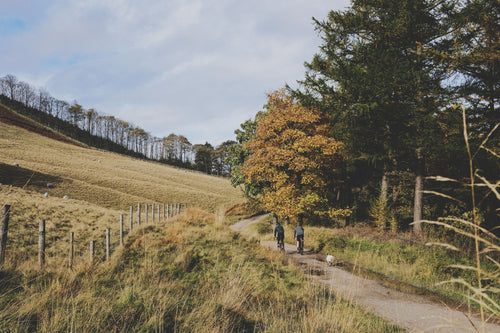
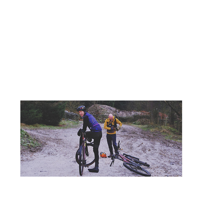
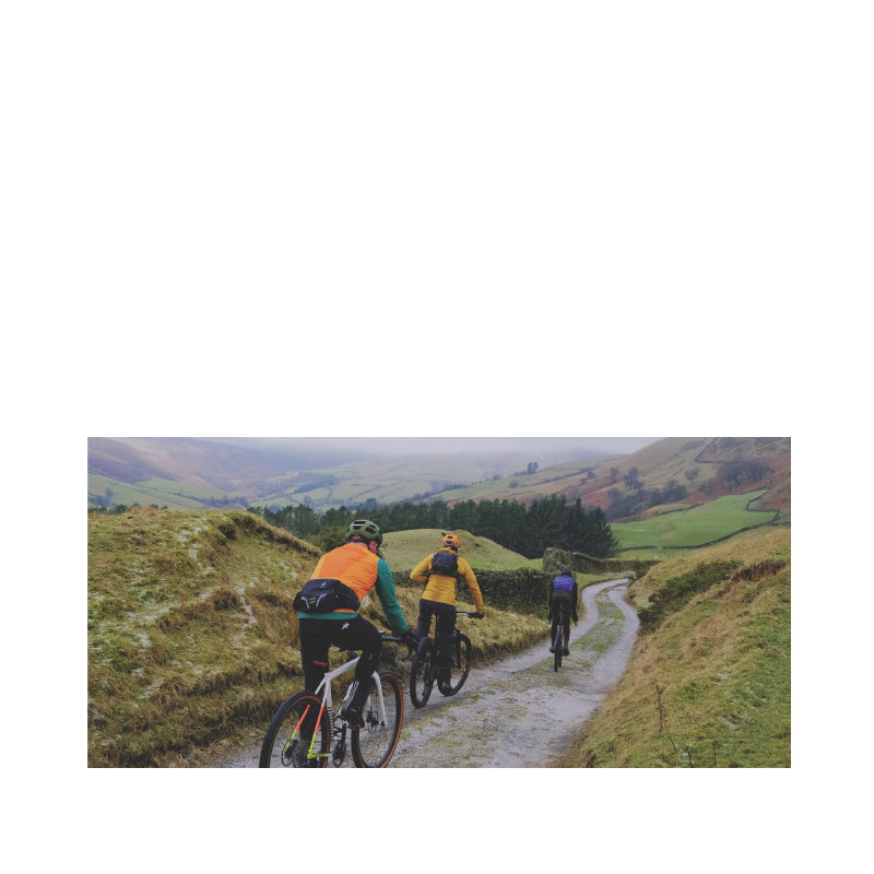
We do most of the development riding for Polaris on the fantastic trails of the Peak District. That’s why we’ve started our classic route collection with Tom’s Ladybower Gravel 8.
Because we love versatility and value here at Polaris the 35km figure of eight layout also means it’s actually two routes in one. The 20km top loop is mostly flat with one long but steady climb after 6km and it’s great for gravel bikes. The 15km southern loop creeps more towards MTB territory as it includes a stinker of a climb and a rougher descent. If you’re confident of your skills and fitness it’s a wonderful wild ‘locals only’ addition with superb panoramic views.
More advanced riders can add the famous Roman Road section up to Hope Cross if they want more of a challenge. Alternatively if you want extra gentle gravel miles extend the loop around Derwent Water at the start.
Whatever you choose to ride it mixes beautiful lakeside and far reaching views with forest climbs, farm track descents and mostly minor roads. As it’s well surfaced it works in any weather and with all tyre types too, though we wouldn’t recommend doing it on 25mm road tyres like Tom did once.
TOM’S LADYBOWER GRAVEL 8
35KM, 850M VERTICAL
Start and finish point - Heatherdene car park which is pay and display. If you’re coming from the south or by train though then you could start/finish at Hope or Bamford.
Make sure you download the route to your device, and watch the Strava fly through and ride video for a preview of the route and a rolling intro to the team. Check in every month for a new MTB or gravel route as we build up our collection of classics across the UK, and if you see us out filming be sure to come and say hello. We’re a brand built on the love of riding and your feedback from the trails is vital to making the product the best it can be.
Stops & shops
Toilets at Heatherdene car park where you start and finish
Fairholmes at Derwent Dam (6km) has a cafe, toilets and car park
Travellers Rest Pub at Brough (22.8km) but Hope is only 1.5km from here with several cafe’s, toilets and two bike shops
Petrol station with shop just before Bamford station (30.5km)
Ladybower Inn, 1km north of Heatherdene car park or Yorkshire Bridge Inn 1km south are ideal for post ride food and drink.
Watch out for
Ladybower is understandably very popular with walkers and families so be careful if it’s crowded.
Be sure to shut any gates you open and be careful of free range livestock on farm tracks.
The second loop takes you up to nearly 400m and it’s exposed too. Add the Peak District’s reputation for rapidly changing - often for the worse - weather so pack a spare layer just in case.
There’s a short section of the A57 main road after Rowlee Farm and another few hundred metres of main road to Bamford station too. Be careful of pedestrians on the shared bike path at the start and finish too.
Route information
Heatherdene to Fairholmes 0-6km
You’re straight into the glorious lakeside views from a broad shared use pavement opposite the car park. Don’t get too invested in the vista though as even though it was cold enough to freeze our bottom brackets off when we rode it, the path was still busy. We were soon catching up with Christmas stories on our own on the gently rise and fall gravel and back road mix with steep forest on our right shoulder and panoramic views of Ladybower’s north limb. If the reservoir is full then you’ll hear the overflow before you see the spectacular engineered Niagara Falls but either way it’s an impressive site and sight. If you’ve got someone like our Guy in your group he’ll start telling you about how 617 Squadron practiced for their Dambuster raids using Lancaster bombers with broomsticks instead of guns so they could carry their heavyweight beach ball explosives to Germany. Be ready to quickly roll away towards Fairholmes car park and the cafe to escape and if that doesn’t work then hopefully they’ll shut up on the climb that’s coming next.
Fairholmes to Rowlee Farm 6-10km
Doubling back from the mini roundabout for the cafe takes you up past the dam on the service road but then you’ll need to double back through the small gate onto the forest road that starts a 2.5km snake up through the trees. A climb that long sounds pretty grim but it’s a comfortably conversational gradient even with gravel gears. In this case ideal for a chat with our boss Barry about the affordable, essential kit we’d want to wear ethos of Polaris. You can catch that on the ride video above we shot too. As well as the stunning views from the top of the climb where you join the old rocky road towards the old farm buildings of Lockerbrook Outdoor Centre. In normal conditions this is a speedy swoop along dry stone walled double track, but today we were treated to a full ‘Dancing on ice’ experience, just without the sequins or style. Thankfully there were some ribbons of grip between the frozen fingers further down but be ready for the tight switchbacks above Rowlee Farm whatever the conditions. Rolling down to the road you’ll be able to see the potential rocky climb option of the Roman Road up to Hope Cross traversing the far hillside. Gradient and gravity are in your favour though so you’ll soon be turning off onto the lattice ironwork of Haggwater Bridge.

Haggwater bridge to Ladybower Dam 10-18km
It’s more blissfully traffic free gravel track as you follow the River Ashop through waterside meadows on it’s way to help fill Ladybower. Easy grades make it a potentially rapid five miles too, or you can faff about with saddles, snacks and scenic wee stops so much that you’re repeatedly over taken by a runner and her spaniel like we were. Watch out for mountain bikers ejecting onto the trail with varying degrees of control from the infamously steep off piste trails of Winhill too. At the end of the reservoir you can wrap up the loop to a neat 20km of gentle gravel by pushing across the top of the dam. If you’re still feeling frisky though then continue past the dam for the more challenging lower loop of our figure of eight.
Ladybower Dam to Brough 18-22.8km
The re-used railway line path through Thornhill Carr pastures with it’s picnic benches and wildlife sculptures is an unexpected scenic treat and obvious snack stop point at roughly half way round the route. That’ll top you up nicely for the next bit rising road where anyone who didn’t get the gravel bike not mountain bike memo may start to struggle. Or you can just ease up and enjoy the pretty hamlets of Thornhill and Aston while taking in the views of the Hope Valley that will open out before you. Your climbing will be repaid with a rapid descent down into the valley before you dogleg across the main road to Hope next to Navio Roman Fort. You’re actually on Roman Road for a few hundred metres through Brough before you peel up onto the climb of Shatton Moor.


Brough to Shatton Mast 22.8-25.6km
Turning off the Roman Road the first road section is steep enough to be siege situation not an easy victory on gravel gears. That then gives way to steeper, looser, rock based farm track that you’ll need to be as fit and strong as Tom, ooofff. Add increasing amounts of ice and Shatton Moor genuinely shat on the chances of most of us making it up dab free. Enjoying the face built into the dry stone wall is a perfect excuse to stop halfway up the hill if you’re struggling though. You can also admire the planning insanity that allowed Hope’s towering cement works to be built into the otherwise beautiful heart of the Peak District before finishing your crawl to the summit. The panoramic views from here are truly fantastic though and the whole moor has that wonderful sense of forgotten wildness that only locals ever visit.
Shatton Mast to Bamford Station 25.6-30.1km
The emptiness lets you really enjoy the first section of farm track descent and rigid riders will be glad of the hole filling maintenance going on when we rode past. The loose rock fill of the next bit of trail definitely favours bigger tyres and suspension rather than overgrown road bikes though. Especially if you want to enjoy the glorious views up towards Ladybower and across towards Stanage Edge. The surface on the remaining road descent into Shatton itself is random enough to need treating with caution and make sure you kill your speed before you reach the handful of pretty stone houses and T-junction at the bottom. From here a couple of hundred meters of main road and a sneaky back alley short cut take you to Bamford station. Not in itself a particularly remarkable pair of platforms, but still a top destination for instagram tourists due to a location labelling mistake on a viral image from the Pride & Prejudice movie. Yes really.
Bamford Station to Heatherdene
Once you’ve stopped posing for social media, dive off the main road and onto the bridleway, crossing the river Derwent before turning north onto the disused railway line you’ll remember from before. Or not in our case, which meant we ended up adding an extra road climb which we could have done without after Tom tore our legs off over Shatton Moor. Happily for our hapless navigation both choices end up at the same spot though so it’s time to say hello to the wildlife sculptures of Thornhill Carr meadows again as you head back to Ladybower dam. After the obligatory gawp at the swirling plughole over the dam wall, push your bike across the dam top footpath to the shared use path on the far side. Again this was busy even in freezing conditions on a Friday so take the last km easy to make the most of the views back across Ladybower, Winhill and the middle section of the ride.